Which lone worker/tracking app or device??

So much that I could say about this.

But, to simplify, if relying on mobile phone communications, on whatever network, pay no attention to the particular network's coverage BS optimistic approximations. Go straight to the Ofcom coverage maps, which will show you the reality of what you can expect. Precisely.

View mobile availability - Ofcom Checker It may seem difficult to use, but not really. Start off with your postcode, house number, gets you in. Then scroll down and click on "View map of available services". Now you are in properly in and can scroll and zoom around the entire country in very fine detail, select network, indoor, outdoor, voice, data (3G, 4G or 5G) and see what the current situation is likely to be.

You might be amazed at how poor coverage is, or non-existent, over huge areas of countryside. As many of us already realise.

So, any lone worker service that only uses mobile network coverage, can only work where there is coverage.

Beyond that is the province of satellite communication. The private companies use either Iridium, truly global, or Globalstar, which is not. If choosing something using Globalstar, Spot etc. be very aware of its limitations particularly at higher latitudes.

In future things may change, utterly, particularly some of the things likely coming to Starlink. SpaceX Starlink service could come to iPhone and Android through satellite hotspot

All these devices rely on GPS as well for location information, which can also be fickle. Just as can be their satellite links, though Iridium is undoubtedly the most solid, all subject to needing good sky view, uninterrupted by e.g. tree cover, never mind being in say a ravine or unsuitable topology.

They also do not communicate directly with the search and rescue services, each one uses private, for profit, organisations, who then liaise with the proper coordinators.

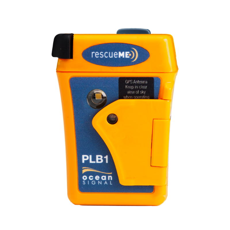
A PLB or EPIRB however uses the Cospas/Sarsat system which is totally different, vastly more resilient, activate one of these and it is absolutely your best chance of directly getting help. As promptly as possible. Globally. But only ever to be used when you absolutely need it. They will keep on reaching out for at least 24 hours to the Sarsats, on 406 MHz (rather than the microwave links used by the messenger devices), even if they can't get a GPS fix they can be located within a few hours, to within a few km, whist also beaming a signal at 121.4 Mhz the international aircraft distress frequency, which can be homed in on by e.g. SAR helicopters.

The other sort of devices have many other uses, all have subscription fees, varying capabilities, many reliant also on connection to a smartphone to use them, a current article worth reading is at The 5 Best Satellite Messengers of 2022

That article title is incorrect, these are not personal locator beacons, they are satellite messengers, which is a completely different thing. Sure they all usually have a way to alert search and rescue coordinators, but that is not their primary function.

For an example of subscription fees for these things, see inReach® Professional Subscription Plans | Garmin

Fundamentally try not to put yourself in a position where you think you can rely on one of these as a "get out of jail free" card. You cannot, even if they work, and SAR can get to you, sooner or later, you must be prudent and self reliant as well.
I just use my Iwatch

Tracks me .
If I fall and hurt myself , it will call emergency services , if I’m out cold at the bottom of a ditch it will detect my slip/fall and will contact my misus and emergency services and give them my location .

They have OS maps , weather warnings ,total hands free the list goes on .

An apple Iwatch 7 saved a local to us farmer mate at the start of the year when he had a heart attack while sub-soiling in a field all on his own.

I almost forgot I also carry a Garmin fortrex 701 ballistic edition too . Got to have a plan B .
Some, not all, apple watches can detect a "hard fall" then a period of immobility, then place a call to your contact, and emergency services. Assuming that there is a mobile network signal. They do not do this if/when they detect a "heart attack" Glad it worked for your farmer mate.

As for your Garmin, what's that going to do, tell you where you are ? Unless you can then call that in somehow

If you have got mobile coverage, place a call to 999 or better 112, from a smartphone, and the emergency services will automatically get your coordinates either precisely from the gps in your phone, or if no gps coverage, nor say Google's spooky location based on nearby known WiFi points may be able to triangulate your position, though this wont work well if you aren't surrounded by multiple cell towers, as in when you are already in poor coverage.

Advanced Mobile Location - Wikipedia

If you use Android, like me, you can share your location in real time with others who you allow. I do this with my family and friends when getting together, works well. You could do this as a lone worker tracking method, of course it also needs a mobile signal to operate.

https://support.google.com/maps/answer/7326816?hl=en-GB&co=GENIE.Platform=Android
 
Hi, I go stalking on my own about 4 times a week over many different estates /farms. Often knowbody actually knows where I am. I would like my wife to know where I am if anything were to happen she could then point the landowners or friends in the right direction. Much of the ground I cover has little or no signal. Does this rule out the phone based apps? If so doe I need a sattelite linked device? If so what do others use and recommend.....obviously don't want to spend a fortune.
Any help much apprceiated, George
Just go to WhatsApp and share live location simples and free
 
Just go to WhatsApp and share live location simples and free
Perhaps you are missing this point by @liongeorge "Much of the ground I cover has little or no signal. Does this rule out the phone based apps? If so doe I need a sattelite linked device? "

I rather think so.

Never tried WhatsApp seems like just another of many such ways, maybe another string to peoples bow to consider, still requires mobile phone signal, not just basic audio/2G but data 3G or 4G, and minimum update period 15 minutes. WhatsApp Live Location Sharing: How to Send Live Location to Your Contacts on WhatsApp - MySmartPrice

Basically if you just want others to be able to keep a track of where you are, and there is mobile coverage all over there, then there are many many ways of doing this, for free.

But if you want something that works anywhere, and can call in emergency services when truly needed, something rather better is required. Time was when protective parents would "bug" their childrens' 'phones, or partners' phones, to spy on their movements, maybe can still be done, but nowadays rather frowned upon.

So many scenarios, from anxious partner worrying about why you've not got home on time or called in to say delayed, maybe as simple as battery on phone run flat, (no phone based solution will counter that possibility) to genuine regular lone workers in areas of no mobile coverage who need completely different solutions, even just to clock in and out.
 
Never tried WhatsApp seems like just another of many such ways, maybe another string to peoples bow to consider, still requires mobile phone signal, not just basic audio/2G but data 3G or 4G, and minimum update period 15 minutes. WhatsApp Live Location Sharing: How to Send Live Location to Your Contacts on WhatsApp - MySmartPrice
I did a trial a couple of years ago carrying 2 iPhones out in a stalking area where there was good mobile signal with others remotely watching. Throughout there was a difference in reported location which at its worst was over 5 miles! I have to use it frequently as a stalking safety measure but with the errors in reported positions and patchy mobile signal it’s about as useful as a chocolate fireguard!

As per my earlier post, I now carry a Bivy Stick for my piece of mind.
 
I did a trial a couple of years ago carrying 2 iPhones out in a stalking area where there was good mobile signal with others remotely watching. Throughout there was a difference in reported location which at its worst was over 5 miles! I have to use it frequently as a stalking safety measure but with the errors in reported positions and patchy mobile signal it’s about as useful as a chocolate fireguard!
Android mobile phone phone "location accuracy services" make use of the phone's internal gps, nearby known WiFi spots, cell site information, sensors such as the accelerometer and the magnetometer (if your phone has a magnetometer/compass, not all do).

Then come up with a location based on a fusion of this data. For Android you can control some of this, see Manage your Android device’s location settings - Google Account Help

I don't know how quite how iPhones work, but it is something similar. Better or worse, I don't know. Either way, the location provided by a phone can be quite variable in accuracy, unknown to the user.

How Accurate Is Your iPhone's Location? Full Details!:

the exact accuracy can vary depending on how strong your iPhone’s signal is, and what method it’s using to determine your location.
This is because Share My Location uses the exact same methods described previously to approximate the location of your device. While Wi-Fi mapping and GPS can be accurate within a few meters, this isn’t always the case. If your signal isn’t strong, the weather is bad or you’re under a heavy structure, it’s possible that it may not even be accurate within 1,000 meters.
So while you can usually rely on Share My Location (and other location-based features like ‘Find My iPhone’), the answer is always going to be “it depends.”


I have verified this myself, by shielding my ' phone's sky view (as may occur naturally when in dense woodland) and watched the location wander about, still some sort of location but achieved without any gps input. In one place I frequent, an ancient wood in an area of poor mobile signal it is fine when I have GPS in the open, but as soon as into the wood all it has is the weak mobile network to guess from, obviously no WiFi locations either. Then, my particular mapping app. shows me directly the circle of confusion about my location, which can be dramatically large, a km or more. So I try not to get lost in the woods by relying on my phone, use the old fashioned methods instead, map, compass etc. and try to note my path backwards, in case I have to backtrack.

It is a pity that mobiles do not directly tell you this, though there are apps that can do so for you. Unless you know you have a good fix, you cannot place too much faith in apps abilities to locate you, nor to guide you to a location. Though they could perfectly well display a location accuracy figure, or even just something like green amber red, they do not. Likewise you cannot expect such good precision from say a mobile phone kept in a pocket or buried in a bag, as you could if it was more suitably positioned, when recording a track.

Actually if you turn off location accuracy the phone is forced to only use gps, which might even be more desirable than accepting the other methods. Maybe better to know that you have no GPS than to press on regardless, not realising that all you have is maybe some weak inaccurate cell site triangulation.

Location accuracy: Manage your Android device’s location settings - Android Help

When you have Google Location Accuracy turned on, your phone uses these sources to get the most accurate location:
GPS
Wi-Fi
Mobile networks
Sensors (such as accelerometer)
Google may collect location data periodically and use this data in an anonymous way to improve location accuracy and location-based services.

When you turn off Google Location Accuracy, your phone uses GPS and sensors, like accelerometer, to determine location. GPS can be slower and less accurate than other sources.

To help responders find you quickly, your phone's location can be sent when you dial or text an emergency number, like when you dial 911 in the US or 112 in Europe.
If Android Emergency Location Service (ELS) works in your country or region and on your mobile network, and you haven't turned ELS off, your phone will automatically send its location to first responders through ELS. If ELS is off, your mobile carrier might still send the device's location during an emergency call or text.

ELS is only activated when you call or text a local emergency number
During your emergency call, ELS may use Google Location Accuracy and other information to get the most accurate location possible for the device.
Your phone sends its location to authorized emergency partners for the purpose of helping emergency services locate you. Your location is sent directly from your phone to emergency partners.


See also Google Location Sharing: Share your real-time location with others - Android - Google Maps Help
As per my earlier post, I now carry a Bivy Stick for my piece of mind.
As I understand it, a Bivy Stick, or any similar satellite communicator, uses only GPS, or a fusion of e.g. GPS (USA), and Glonass (Russia), Beidou (China), Galileo (EU but not quite fully in service yet) for location. Together with a satellite link, Iridium or Globalstar. There are also a few using Inmarsat. All these systems need good sky view (as of course does GPS). I see their advantage over a mobile phone simply as when being in an area where there is no mobile phone coverage. Otherwise a mobile phone alone can be a workable solution. Recognising that these also can have varying degrees of location precision.

Frankly a dedicated GPS navigator is likely to work better than the GPS modules embedded in phones, or other devices, with compromised antenna designs, for packaging reasons.

The satellite link is still reliant on a good sky view. If you have that you very probably also have good GPS. But if you don't, then they can't help. Whereas a mobile phone without a view of the sky still might still be able to give less precise location, but still useful. And of course still communicate. I see them as being complimentary. The Garmin InReach can be operated without a cellphone app, but the Bivy Stick does require one, except for pushing the emergency button, or I think sending a pre-programmed "I'm all right" text.

These things do need to be recharged, probably daily, if you are going to actually use them for tracking, or to receive texts from others. I daresay they last much better if only switched on when wanting to send a text, or report a position, but that's rather missing the point.

Plbs and Epirbs however are quite different. The 406 Mhz frequency is far less subject to disruption, they communicate directly to your governent's SAR coordination centre, not filtered through some intermediate private company, and even if there is no GPS available for a precision location, they can still be located, over a period of hours. And keep on transmitting for at least 24 hours, including the a21 MHz signal to be homed in on by a helicopter, or simply noticed and reported by an overflying civil or military aircraft. Hopefully never to be used, but if needed the special batteries used are qualified to last for many years until needed. No subscription fees.

The latest generation of Plbs even have a two way link, so that once activated the user can see when the COSPAS/SARSAT system has received their emergency transmission, for reassurance, or as a prompt to try moving the PLB to a more suitable place. This is thanks to the new Sarsat transponders fitted to the EU's Galileo navigation satellites. As yet the return link service status is "usable", not "fully operational", it is early days. The forward link service however is largely "fully operational", albeit still with a few gaps in the constellation. But these new devices used both GPS and Galileo, so will fill in any gaps until Galileo is fully operational, nearly there.

ACR - ResQLink RLS PLBs have Cospas-Sarsat & European Approval!

Offering two-way confirmation between 406 MHz beacon owners and Search and Rescue for the first time, the new technology can only be included in the latest distress beacons that are able to receive Galileo signals, so we are excited to offer one of the first RLS-equipped PLBs to boaters, hikers, pilots, hunters and all outdoor enthusiasts.
Using the next-gen network, anyone activating a ResQLink PLB can expect their beacon to be located within 100 meters (328 feet), 95% of the time, within 5 minutes of the distress signal.
 
Just go to WhatsApp and share live location simples and free
As I replied earlier, we are required to use WhatsApp and not only does in not work at all in no/poor signal areas, my second post above relating the 5 mile error was what was showing on the ground when I stalked with WhatsApp live location running 2 phones simultaneously on me. If there is GSM coverage then I find Apple's "Find my Friends/Devices" to be more accurate/reliable than WhatApp's Live Location but it needs GSM signal coverage. Where there is none, you need satellite (In Reach, Bivy, etc) to report positions/message or a PLB for a one-off shout-out for help. Simples:tiphat:
 
Hmm...PLBs sound good but it would be good if someone (my wife) can track me from home. I believe PLBs are only used in an emergency situation to give location. I need to be tracked really as it would allow others ie the landowner or my stalking buddy who is local and knows all my ground to be able to locate me if it were'nt a blue lights situation or heaven forbid I wasn't able to push the button.. And they could probably get there quicker. Also it wouild give my wife reassurance and know when to put my tea on. ;) So am looking at the other satelite devices.
 
999 calls are across all the networks ! ie if you use vodaphone in the North highlands it will work on any service provider . We have proper rubbish cell phone service here , i rarely carry a phone now its a WFT
 
Android mobile phone phone "location accuracy services" make use of the phone's internal gps, nearby known WiFi spots, cell site information, sensors such as the accelerometer and the magnetometer (if your phone has a magnetometer/compass, not all do).

Then come up with a location based on a fusion of this data. For Android you can control some of this, see Manage your Android device’s location settings - Google Account Help

I don't know how quite how iPhones work, but it is something similar. Better or worse, I don't know. Either way, the location provided by a phone can be quite variable in accuracy, unknown to the user.

How Accurate Is Your iPhone's Location? Full Details!:

the exact accuracy can vary depending on how strong your iPhone’s signal is, and what method it’s using to determine your location.
This is because Share My Location uses the exact same methods described previously to approximate the location of your device. While Wi-Fi mapping and GPS can be accurate within a few meters, this isn’t always the case. If your signal isn’t strong, the weather is bad or you’re under a heavy structure, it’s possible that it may not even be accurate within 1,000 meters.
So while you can usually rely on Share My Location (and other location-based features like ‘Find My iPhone’), the answer is always going to be “it depends.”


I have verified this myself, by shielding my ' phone's sky view (as may occur naturally when in dense woodland) and watched the location wander about, still some sort of location but achieved without any gps input. In one place I frequent, an ancient wood in an area of poor mobile signal it is fine when I have GPS in the open, but as soon as into the wood all it has is the weak mobile network to guess from, obviously no WiFi locations either. Then, my particular mapping app. shows me directly the circle of confusion about my location, which can be dramatically large, a km or more. So I try not to get lost in the woods by relying on my phone, use the old fashioned methods instead, map, compass etc. and try to note my path backwards, in case I have to backtrack.

It is a pity that mobiles do not directly tell you this, though there are apps that can do so for you. Unless you know you have a good fix, you cannot place too much faith in apps abilities to locate you, nor to guide you to a location. Though they could perfectly well display a location accuracy figure, or even just something like green amber red, they do not. Likewise you cannot expect such good precision from say a mobile phone kept in a pocket or buried in a bag, as you could if it was more suitably positioned, when recording a track.

Actually if you turn off location accuracy the phone is forced to only use gps, which might even be more desirable than accepting the other methods. Maybe better to know that you have no GPS than to press on regardless, not realising that all you have is maybe some weak inaccurate cell site triangulation.

Location accuracy: Manage your Android device’s location settings - Android Help

When you have Google Location Accuracy turned on, your phone uses these sources to get the most accurate location:
GPS
Wi-Fi
Mobile networks
Sensors (such as accelerometer)
Google may collect location data periodically and use this data in an anonymous way to improve location accuracy and location-based services.

When you turn off Google Location Accuracy, your phone uses GPS and sensors, like accelerometer, to determine location. GPS can be slower and less accurate than other sources.

To help responders find you quickly, your phone's location can be sent when you dial or text an emergency number, like when you dial 911 in the US or 112 in Europe.
If Android Emergency Location Service (ELS) works in your country or region and on your mobile network, and you haven't turned ELS off, your phone will automatically send its location to first responders through ELS. If ELS is off, your mobile carrier might still send the device's location during an emergency call or text.

ELS is only activated when you call or text a local emergency number
During your emergency call, ELS may use Google Location Accuracy and other information to get the most accurate location possible for the device.
Your phone sends its location to authorized emergency partners for the purpose of helping emergency services locate you. Your location is sent directly from your phone to emergency partners.


See also Google Location Sharing: Share your real-time location with others - Android - Google Maps Help

As I understand it, a Bivy Stick, or any similar satellite communicator, uses only GPS, or a fusion of e.g. GPS (USA), and Glonass (Russia), Beidou (China), Galileo (EU but not quite fully in service yet) for location. Together with a satellite link, Iridium or Globalstar. There are also a few using Inmarsat. All these systems need good sky view (as of course does GPS). I see their advantage over a mobile phone simply as when being in an area where there is no mobile phone coverage. Otherwise a mobile phone alone can be a workable solution. Recognising that these also can have varying degrees of location precision.

Frankly a dedicated GPS navigator is likely to work better than the GPS modules embedded in phones, or other devices, with compromised antenna designs, for packaging reasons.

The satellite link is still reliant on a good sky view. If you have that you very probably also have good GPS. But if you don't, then they can't help. Whereas a mobile phone without a view of the sky still might still be able to give less precise location, but still useful. And of course still communicate. I see them as being complimentary. The Garmin InReach can be operated without a cellphone app, but the Bivy Stick does require one, except for pushing the emergency button, or I think sending a pre-programmed "I'm all right" text.

These things do need to be recharged, probably daily, if you are going to actually use them for tracking, or to receive texts from others. I daresay they last much better if only switched on when wanting to send a text, or report a position, but that's rather missing the point.

Plbs and Epirbs however are quite different. The 406 Mhz frequency is far less subject to disruption, they communicate directly to your governent's SAR coordination centre, not filtered through some intermediate private company, and even if there is no GPS available for a precision location, they can still be located, over a period of hours. And keep on transmitting for at least 24 hours, including the a21 MHz signal to be homed in on by a helicopter, or simply noticed and reported by an overflying civil or military aircraft. Hopefully never to be used, but if needed the special batteries used are qualified to last for many years until needed. No subscription fees.

The latest generation of Plbs even have a two way link, so that once activated the user can see when the COSPAS/SARSAT system has received their emergency transmission, for reassurance, or as a prompt to try moving the PLB to a more suitable place. This is thanks to the new Sarsat transponders fitted to the EU's Galileo navigation satellites. As yet the return link service status is "usable", not "fully operational", it is early days. The forward link service however is largely "fully operational", albeit still with a few gaps in the constellation. But these new devices used both GPS and Galileo, so will fill in any gaps until Galileo is fully operational, nearly there.

ACR - ResQLink RLS PLBs have Cospas-Sarsat & European Approval!

Offering two-way confirmation between 406 MHz beacon owners and Search and Rescue for the first time, the new technology can only be included in the latest distress beacons that are able to receive Galileo signals, so we are excited to offer one of the first RLS-equipped PLBs to boaters, hikers, pilots, hunters and all outdoor enthusiasts.
Using the next-gen network, anyone activating a ResQLink PLB can expect their beacon to be located within 100 meters (328 feet), 95% of the time, within 5 minutes of the distress signal.

Some useful insights there @Sharpie, thanks. Can I ask, what made you choose the Bivy stick over the Inreach Mini?

I've a Fastfind, but starting to see the benefit of a 2 way chat with family and am looking at the Inreach, would be interested in your comments.
 
Can I ask, what made you choose the Bivy stick over the Inreach Mini?
I’m not sure that @Sharpie has a Bivy - it was me who originally posted about this device earlier in the thread.

To answer your question, it was primarily on how I use my tech whilst stalking. I previously used to carry a Globalstar Sat phone as my emergency device but whilst that did give me the flexibility of voice calls, there was no position reporting, quick emergency call features or messaging which I find very useful.

As I said earlier, on most of my ground I am required to use WhatsApp live location despite its failings. As I also mentioned in another current thread on here about iWatches, I use a Series 7 as the front end to my phone so whilst out stalking, my iPhone sits slipped into the elasticated sleeve on the top of my AGC bino pack. Having lost an iPhone up on Arran (thankfully found due to Apple’s excellent Find my Device App), it now also sits in an orange silicon case (good grip and easy to see in long grass - dropped one was black and difficult to see) with a plastic tab that comes out of the charging cable slot to which I attach a short stainless steel coiled tether (Amazon). WhatsApp does not have an iWatch App but there is a third-party App called WatchChat that means all WhatsApp messages come up on my iWatch with a silent buzz. I use the phone for OS Maps, OS locate for carcass shot/strike site positions (screenshot saved to photos) and always take a picture of the animal and often the dogs too. So, my iPhone and iWatch are in regular use whilst stalking. The watch holds good charge (enough for 2 days use) and I carry a very small power bank and cable in my AGC pack as an emergency charger for the phone - so far never needed.

Looking at the various satellite options I didn’t want yet another piece of tech that operated on its own rather, I liked the idea that all I had to do was to turn it on at the start of my stalk and all Comms/position reporting etc could be done through my phone. The Bivy sits in the Molle on the left shoulder of my AGC bino pack so it has good satellite visibility at all time and I can easily see the status/message lights. From the App on my phone I can set it to send regular position reports automatically at the frequency appropriate to the terrain/stalk with no further user involvement and if I need to send a specific message, I can quickly do it via the phone App. That has full access to my phone contacts so it can quickly send messages to any phone or email in my contacts. If the Bivy shows that it has received a message, I can quickly read it by opening the App on the phone.

It’s a bit of a long winded reply but the simple answer is that the Bivy fits my tech use much better when stalking than the stand alone In Reach. The Bivy uses a UK mobile number, is billed in GBP, has worldwide coverage and unused credits roll over so when I go to a Scotland I can use the “stored” credits more intensively over the week. It’s small, is made by ACR (who are one of the primary manufacturers of PLBs and GMDSS SOLAS safety devices) charges quickly and is very unobtrusive in use - all I do is turn it on, turn it off and occasional check for any messages received if I don’t check in the phone App. I sourced mine through GTC (as I did my previous Sat phone Globalstar airtime) and they are very good, efficient and very helpful.

That’s how I use it so that it fits how I stalk - other options are available as they say that may better suit others needs or stalking habits. Hope that helps.
 
Thanks @wytonpjs, really appreciate that.

I'd been set on an Inreach as an add-on to my Fastfind, but that's given me food for thought. Great to get your thought process on why you went for the Bivy, makes sense.
 
999 calls are across all the networks ! ie if you use vodaphone in the North highlands it will work on any service provider . We have proper rubbish cell phone service here , i rarely carry a phone now its a WFT
It is not quite as simple as that. Have a read of Demystifying 999 calls on a mobile phone - Cumbria First Aid Training Courses

In particular, pay attention to:

In most circumstances making a 999 call on a mobile phone will simply require a signal and, once the emergency dispatcher has recorded all the necessary information, the ball starts rolling to summon emergency help. The emergency dispatcher will stay on the phone if they deem it necessary to i.e. to talk the caller through how to carry out CPR. In remote outdoor settings calls should be placed to the police who will pass all the necessary information about your emergency to a rescue team in your locality. It is quite typical that the rescue team will call you back to gather further information, particularly about your location.

It is important to note that when a phone that’s not using their home network (camped-on) can only place a 999 call. They cannot receive a call back on that network, even if the inbound call is from the emergency services.

So if the emergency services needed to call you back (i.e. to update their progress or to gather further information about your location) they will be unable to do so unless you are connected to your home network. This may not seem that vital if you are in an urban setting when an ambulance is only 20 minutes away (if you are lucky!) however this would be incredibly significant in a remote settings where the use of search & rescue teams may be the only option of rescue and a two-way conversation will be more important – good to know!


As it happens had to deal with this once, at my place in deepest darkest North Norfolk, visited every couple of weeks for a few days. , when a neighbour knocked on my door, it seems he had been waiting for me to turn up, nobody else liked him but I rather did, very intelligent man with an horrific back story (ex military) nice and compassionate with it., despite him being a full on alcoholic, but also a serious drug user. Hi Jon, saw you arrive, have taken an overdose of all my meds, here are the packets, plus a lot of heroin. And swigged down a bottle of vodka.. Am about to collapse, please call for help and look after my dog (a huge senile bewildered old Newfoundland)., here are my keys. My witty comment, what only one bottle, we both know you are a two bottles of vodka/day chap. Well, that's what I might have said previously, whilst also enquiring how smacked up he also was before letting him in or turning him away.

What a cry for help.

Then keeled over outside before he had even come inside. Bugger. No signal on my network, as usual, but 999 got through somehow. Ambulances despatched from both Norwich and Kings Lynn, first one got there in half an hour , maybe 45 minutes I think, meanwhile I was doing CPR (yes I also knew he had HIV, but what are you going to do, stand back and watch someone die ?, tested clear afterwards and subsequently) no pulse, not breathing, daren't hang up the phone nor did the 999 people, no way to get back to me otherwise, fortunately battery held up. Damn I was knackered singing the .... "staying alive" theme as I pressed on until the ambulance found me and cracked on for over an hour before they took him away. Visited him a few days later in hospital, but they soon enough discharged him with absolutely no support so he topped himself properly the next day. Managed to pass off the dreary dog to the RSPCA. Aaah well, I did my best, maybe it would have been altogether simpler to have just stood back and closed the door..

i rarely carry a phone now its a WFT
WTF does WFT mean ? I have googled it and found nothing meaningful. Anyway, in the circumstances I have just described no Plb, Sat. messenger or other gadget would have been the least bit of use. Simple mobile phones, preferably "smart" ones, are nowadays essential, like it or not. First thing I do before stepping out of the house is check keys, wallet, mobile all present.
 
I’m not sure that @Sharpie has a Bivy - it was me who originally posted about this device earlier in the thread.

To answer your question, it was primarily on how I use my tech whilst stalking. I previously used to carry a Globalstar Sat phone as my emergency device but whilst that did give me the flexibility of voice calls, there was no position reporting, quick emergency call features or messaging which I find very useful.

As I said earlier, on most of my ground I am required to use WhatsApp live location despite its failings. As I also mentioned in another current thread on here about iWatches, I use a Series 7 as the front end to my phone so whilst out stalking, my iPhone sits slipped into the elasticated sleeve on the top of my AGC bino pack. Having lost an iPhone up on Arran (thankfully found due to Apple’s excellent Find my Device App), it now also sits in an orange silicon case (good grip and easy to see in long grass - dropped one was black and difficult to see) with a plastic tab that comes out of the charging cable slot to which I attach a short stainless steel coiled tether (Amazon). WhatsApp does not have an iWatch App but there is a third-party App called WatchChat that means all WhatsApp messages come up on my iWatch with a silent buzz. I use the phone for OS Maps, OS locate for carcass shot/strike site positions (screenshot saved to photos) and always take a picture of the animal and often the dogs too. So, my iPhone and iWatch are in regular use whilst stalking. The watch holds good charge (enough for 2 days use) and I carry a very small power bank and cable in my AGC pack as an emergency charger for the phone - so far never needed.

Looking at the various satellite options I didn’t want yet another piece of tech that operated on its own rather, I liked the idea that all I had to do was to turn it on at the start of my stalk and all Comms/position reporting etc could be done through my phone. The Bivy sits in the Molle on the left shoulder of my AGC bino pack so it has good satellite visibility at all time and I can easily see the status/message lights. From the App on my phone I can set it to send regular position reports automatically at the frequency appropriate to the terrain/stalk with no further user involvement and if I need to send a specific message, I can quickly do it via the phone App. That has full access to my phone contacts so it can quickly send messages to any phone or email in my contacts. If the Bivy shows that it has received a message, I can quickly read it by opening the App on the phone.

It’s a bit of a long winded reply but the simple answer is that the Bivy fits my tech use much better when stalking than the stand alone In Reach. The Bivy uses a UK mobile number, is billed in GBP, has worldwide coverage and unused credits roll over so when I go to a Scotland I can use the “stored” credits more intensively over the week. It’s small, is made by ACR (who are one of the primary manufacturers of PLBs and GMDSS SOLAS safety devices) charges quickly and is very unobtrusive in use - all I do is turn it on, turn it off and occasional check for any messages received if I don’t check in the phone App. I sourced mine through GTC (as I did my previous Sat phone Globalstar airtime) and they are very good, efficient and very helpful.

That’s how I use it so that it fits how I stalk - other options are available as they say that may better suit others needs or stalking habits. Hope that helps.
I use a Garmin Inreach GPS66 and it will do all of that as well as work stand alone if needed with full GPS mapping, tracking navigation functions. There is a phone app for tracking, email and texting and more. Have to say I rarley use the phone app but nice to have it there if needed. Always worried that the phone could run out of battery leaving me no way to communicate with a system like the Bivy, but it is simple and effective a solution. Also the tariff for the Garmin is much less as a basic plan, but would be similar with live tracking and more free texts. I dont use it for stalking on any of my ground as there is phone coverage but playing away in more remote places, its nice to have the security.
 
If so what do others use and recommend.....obviously don't want to spend a fortune
I have a Doro with a payg cim.
I has a EM button the pings a pre configured txt to your list of 1st responders .
It adds a grid ref of your location to the txt.

Ok, you have to press the button and you need a little bit of signal, but it's a good 80/20 solution for me.

The good lady takes it jogging too
And I've also bought one for my mum who's 92.
She just needs to remember to take it with her...

20221126_190546.webp
 
I have a Doro with a payg cim.
I has a EM button the pings a pre configured txt to your list of 1st responders .
It adds a grid ref of your location to the txt.

Ok, you have to press the button and you need a little bit of signal, but it's a good 80/20 solution for me.

The good lady takes it jogging too
And I've also bought one for my mum who's 92.
She just needs to remember to take it with her...

View attachment 282627
Here is me for a second, thinking 92 is getting on a bit for going jogging with the Daughter in law LOL
 
  • Like
Reactions: MAH
I have a Doro with a payg cim.
I has a EM button the pings a pre configured txt to your list of 1st responders .
It adds a grid ref of your location to the txt.

Ok, you have to press the button and you need a little bit of signal, but it's a good 80/20 solution for me.

The good lady takes it jogging too
And I've also bought one for my mum who's 92.
She just needs to remember to take it with her...

View attachment 282627
Here was me, thinking the signal had died on this thread! 👍😘
 
Back
Top