Orion
Well-Known Member
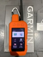
After mucking around with a Garmin Vista for a while I put it back on eBlag, (and turned a profit!), and took the plunge on the Oregon 550t as I could wang it as a business expense.
Loads of interesting features and the camera geotagging of deer taken looks to be a really workable feature to make integrated cull records- thanks whoever mentioned that on another thread.") Also, I can see a use when laying out tracking trails for dogs and tracking 'in anger' etc. etc.
Also, I can see a use when laying out tracking trails for dogs and tracking 'in anger' etc. etc.
Anyhow, we're off to the northern Spain and the Picos de Europa for a couple of weeks, so I'm trying to load up some waypointed routes but have problems in downloading walks in an acceptable format from the web. Everything I get seems to be in HTML which means nothing to the Garmin BaseCamp program. Is it as simple as changing the suffiz to .gpx?
Any other hints and tips, thanks.
Loads of interesting features and the camera geotagging of deer taken looks to be a really workable feature to make integrated cull records- thanks whoever mentioned that on another thread.
Also, I can see a use when laying out tracking trails for dogs and tracking 'in anger' etc. etc.Anyhow, we're off to the northern Spain and the Picos de Europa for a couple of weeks, so I'm trying to load up some waypointed routes but have problems in downloading walks in an acceptable format from the web. Everything I get seems to be in HTML which means nothing to the Garmin BaseCamp program. Is it as simple as changing the suffiz to .gpx?
Any other hints and tips, thanks.

 ), but they are local to me so I could go round there and visit some wrath on them if they didn't come through. Price was £287 'ish plus vat and I put it through the books as a 'business other' expense and I'll argue the toss if or when the day comes. It's got complete European Topo and basic road maps already installed and has several hundred Mb of internal memory available plus will take a micro SD card up to 4Gb - plenty enough for extra maps, photos etc. etc. Garmin also have the entire UK on the Discoverer series OS linked maps - either as micro SD or downloadable - eBlag is already showing some bargains!