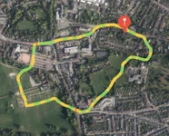
I've seen pictures of aerial photographs (like below) with the line of the trail and the track superimposed. I am aware that there was an app called MotionX which did this but it has been withdrawn...anybody got any alternative suggestions/recommendations?
MapMyRun have an app on iPhone, guess they probably have an android one too.
Also has all the data for elevation and times etc being that it’s aimed at runners.
only problem is that if the volume is turned up it shouts at you with your time for the last mile etc.
I`ve used "real time g.p.s. tracker" app for years now (www.greenalp,com)
Its always on when I`m out feeding or stalking for info and safety. Wife can see exactly where I am too
in real time.
This site uses cookies to help personalise content, tailor your experience and to keep you logged in if you register.
By continuing to use this site, you are consenting to our use of cookies.